Showing posts with label dorset. Show all posts

Monday, 5 January 2009

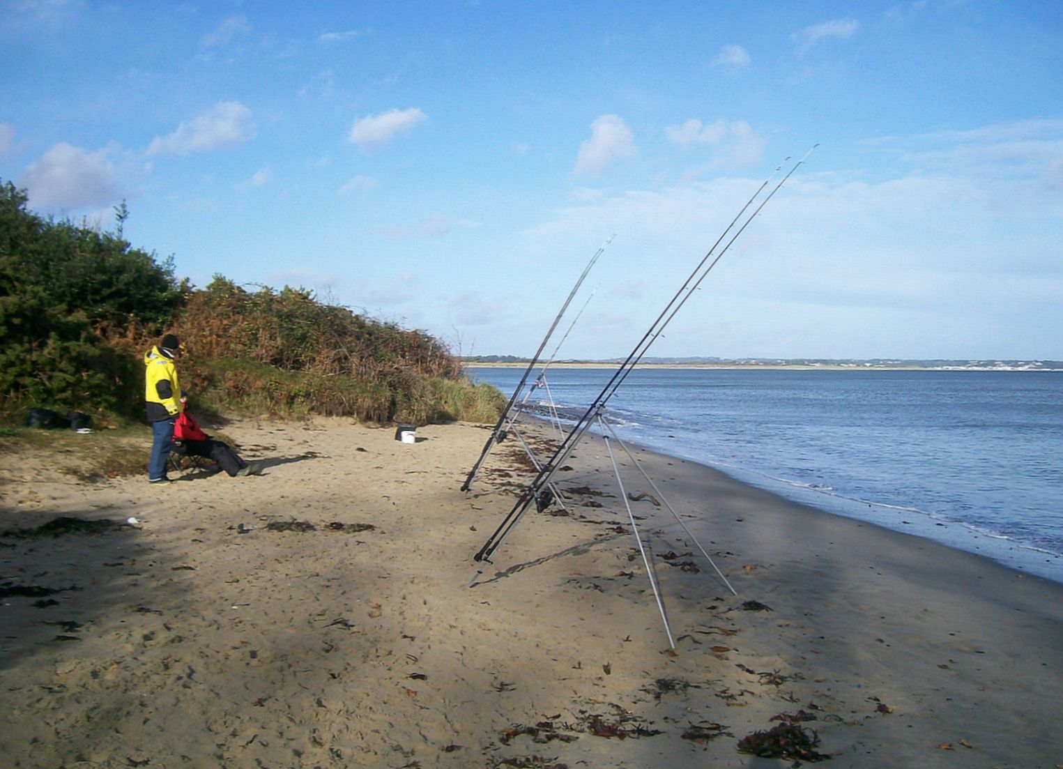
Poole Harbour, Redhorn Point.

Waiting for a flounder, Redhorn Point

Redhorn Point, Witch Farm Oilfield across the water.

As you head from Studland towards the Ferry you will drive uphill around a long sweeping bend and then as the road levels, see a long straight; on your left about 200 yards on is a metal gate ( FP5 on a sign on the gate) with large a rock each side of the gateway. Coming from the ferry, if you've started going downhill and turning left.... you've missed it. Parking is available at the roadside but keep clear of the yellow line. A broad path leads down to the point it is an easy walk with a few muddy patches after rain. There are usually a few boats moored near the point which provide a visual marker to head for.

January day, with ice along the shoreline.

Fishing from the side of the point is onto silt and mud and a good pull on the line is needed to move the weight from the bottom, from the point casting out to the right of the green channel marker pole the sea bed is more sand and shingle. There are some weed patches to negotiate when reeling in to avoid snags.
You can fish this venue with light tackle as distance is not needed, ragworm, mussel or slipper limpets will catch the usual Poole harbour species.... flounder, school bass and eels.

There are no facilities nearby, there is a cafe and toilets back at Knoll Beach (NT) at Studland. Nearest bait and tackle shops are at Wareham, Swanage or Poole.

The venue is child friendly, there is a strip of sandy beach or a close cropped grass area for the ankle-biters to play on within sight of where you will be fishing.Like all fishing marks along this part of the harbour please observe the fire safety rules.... no fires or barbecues. Adders are quite common in heathland, leave them alone and they will not bother you; keep out of long vegetation, there are a great many deer here and they carry ticks which lurk on the long growth waiting for another host to brush against it.


OTHER LOCAL VENUES......Studland................Jerry's Point


Tide Times for the next seven days

updated 17th August 2010
Parking warning !

Parking Warning. The signs say 'no overnight parking'.... this means you may get a ticket for parking at any time during the 'night', even if you stay just a short time.
check the signs, I believe it is between
11pm and 06.30 am


Thursday, 16 August 2007

Poole Harbour, Jerry's Point.

Jerry's Point, looking west back towards Studland Village.
Jerry's Point is a promontory into Poole Harbour of the heathland that forms the Studland Peninsula. Access is via the road from Swanage to the Toll Ferry to Sandbanks. Look for a blue bus stop pole on the south side of the road about half a mile from the ferry; it has Jerry's Point listed as the stop name, opposite is a gated vehicle entrance with pedestrian access to the side. There is free parking alongside the road but keep inside the yellow line and do not park overnight or you will get a ticket. There are toilets back at the Ferry landing near the toll booth. There is a path that runs northwards to Jerry's Point which faces Brownsea Island, to the point is about a four hundred yard level walk but there may be muddy patches after rain . A few safety tips here, do not under any circumstances light a fire because of the risks to the heathland, the area has a big population of deer ( you can see there slot marks in the soil or in the sand on the beach ) so look out for ticks if you have brushed through the heather, also it is not uncommon to see adders here (best not to play with them). On the way out to the point you will pass a well defined path through the heather leading down into Bramble Bush Bay, you can fish along this beach out as far as the houseboats and Gravel Point. The water is shallow and bass and flounder are the targets here. Ragworm is the favoured bait but fish strips, sand eels or slipper limpets can account for the bigger fish.
Bramble Bush Bay with houseboats and Gravel Point in the background.
Fishing at the point is much like fishing other marks in the harbour. Shallow areas hold bass and flounder but little else. From the point you can cast into deeper water in the channel towards Brownsea Island, it is possible to wade out along the shingle spit to spin for bass in the deeper water or into the disturbed water that forms as the tide drops and increases the rate at which water flows around the point.
Generally the fishing is not great but this is compensated by the views and the solitude; it is not a busy mark usually although there are sometimes matches held here. A safe place for children to potter about on the narrow beaches or to paddle in shallow water.

Nearest tackle shops are Swanage Angling , Poole Sea Angling Centre or the shop in Wareham,
Purbeck Angling, 28 South St Wareham Dorset BH20 4LU


Parking warning ! The signs say 'no overnight parking'.... this means you may get a ticket for parking at any time during the 'night', even if you stay just a short time.
check the signs, I believe it is between 11pm and 06.30 am

updated 27:01:12  bus stop details updated


Wednesday, 15 August 2007

Chesil, Ferry Bridge.

Ferrybridge is the name given to several locations, there is a pub, The Ferrybridge Inn, on the right-hand side as you leave Wyke Regis towards Portland. You can get access behind the pub to fish The Fleet which is the area of water between Chesil Beach and the mainland. The main quarry here is bass although some fish the area for flounder.
The next Ferry Bridge is a concrete bridge carrying the road over the inlet to The Fleet from Portland Harbour. There are several places that you can access here to spin or float-fish with mackerel strip or sandeel for gar, mackerel, bass or pollack...... depending on season. The tide pulls strongly through here and fishing is best a couple of hours each side of high. You can bottom fish for the same species although small wrasse will feature most in your catch if you use ragworm.

Under the Ferry Bridge, spinning for bass
Be careful when walking on the sloping concrete apron, it is very slippery where it is covered by the tide and has weed or algae growing on it. The fringes of the water have weed patches so care is needed not to get snagged when retrieving a fish. This venue is quite safe for children and the bridge gives shelter if it rains.

Ferry Bridge, looking west back towards Weymouth.
Wheelchair access is possible to this area via the area to the rear of the pub or via a ramped access at the Portland side of the bridge.( I will have to check if there are any steps, I can't remember seeing any). Some people fish from the bridge itself, this brings the problem of catching the boats that pass in and out of The Fleet. Nearest facilities are at the Ferrybridge car park a few hundred yards east. Don't be tempted to park on the road or in the access roads or tracks. It is usual for a few vehicles to be parked on the grass verge though.
Chesil 'Ferrybridge', looking over The Fleet at low tide from the car park.

The next Ferrybridge location is the car park containing an Information Centre, a snack bar and toilets. The car park is an area levelled by US forces during WWII as part of the D-Day build up. It is now a race track for chavs in the evening and a source of revenue for the council. Pay especial attention to the charges board when you get a ticket.... charges are steep and apply 24 hours a day.
The best fishing spots are said to be to the right, in the above photo you can make out a small structure far to the left. Walk out to here, along the bank of the fleet is easiest ( at low tide you can take a short cut), and then up the bank near to the fenced off area. The fences are to keep people out from the bird nesting area. There are a few noted marks that are wrecks that can be reached by big casters who know where they are. The 'Landing Craft' and the 'Adelaide' are found by following the detailed instructions on this
 site
All manner of fish can be caught in season along this stretch, indeed it would be easier to list those that cannot be caught. Favourite baits, ragworm, mackerel, squid and sandeels. Most likely catch... dogfish.
The area is very popular with holiday-makers bashing out mackerel during the summer and by cod hunters in the winter.
The nearest tackle shops are here.


on and under bridge only.


Monday, 4 June 2007

The Purbecks.

Durlston Bay, looking west; the start of the Purbecks


The Purbecks is the name given to the area of Dorset from Swanage towards Weymouth. The marks along this stretch of coast are characterised by two things, rocky rough ground and long walks. The scenery and quiet solitude of the marks make the walks worthwhile.
Marks along this stretch are Durlston Bay, Tillywhim Caves, Dancing Ledge, Chapmans Pool, Warbarrow Bay, Kimmeridge Bay and Lulworth Cove.
Warbarrow Bay.

Sections of the coast fall within the military firing ranges. Be aware of the danger, notices and red flags indicate the danger area and firing times. Climbing down to the sea is not a good idea unless you are properly equipped for the task, a great many of call-outs for the Swanage Lifeboat crew are to rescue walkers, climbers and anglers trapped at the cliff base.
Few of the marks along this stretch of coast are suitable for young children, Worbarrow is fine, but others require long walks and often,when you get there slippery rocks high above other rocks or water; these are seldom good places for children.
I do not do long walks or rock fishing so any advice on the rocky marks, if added, will be second-hand information
.

The Purbecks, Worbarrow Bay.

Worbarrow Tout, tout is an old word for a lookout point

Worbarrow Bay is south west of Wareham and west of Swanage, it is within a military firing range area and entry times are dependent on range use. The access is usually given at weekends and bank holidays. Notices giving information are on the approach roads along with closing times for car parks. The area was requisitioned during WWII and has changed little since then so there is little or no new building and the area is farmed much as it was in the 1940s; it is a beautiful piece of countryside. Paths are marked by yellow topped posts.... stay on the paths !... if you are stupid enough to leave the paths, the metal objects looking like shells or bombs probably are and will cause you no good at all if they are poked or prodded.
There is a large car park, open from about 6am to 10pm, for which there is a charge of £2 (I think) to be paid into the honesty box. There are toilets on the left after the bridge over a small stream as you turn right to begin the long walk down to the bay. The walk down between trees and grassland is gently sloping until you reach the low cliff by the Tout where it becomes steep. The first part of the beach is sandy and you will be casting onto rough ground for wrasse bass or pollack. If spinning is you preferred method or fishing then make your way left out around the rocky area below the Tout.

Warbarrow Bay, looking west.

To the west the shingle beach becomes steeper and gives way to much deeper water and a cleaner bottom. Flatfish, rays, eels and other bottom feeding fish can be targeted here along with pollack, mackerel, gar and scad to float-fished sandeel or fish strip.. Ragworm will catch most fish here with mackerel or squid as backup or as a tipping bait.The sandy area is most crowded with other beach users so a walk out to the west is recommended to get away from the stone-chuckers, moored boats and swimmers.
The nearest tackle and bait shops are in Wareham, on the right just before the bridge over the River Frome as you leave the town towards Swanage or at Swanage.


Tuesday, 15 May 2007

Poole Harbour & Studland, Studland Beach

Only Google knows why, when searching for fishing in Poole Harbour it dumps you here !
You need to be here, and click on the orange links to different venues

Studland, Knoll Beach looking east towards Poole and Bournemouth.

Studland Beach is one of the best bathing beaches in the country, it is usually crowded in good weather. To the left of Knoll Beach is a popular naturists' area. If you fish here it is best done out of season. Studland is a National Trust property and is reached either by the Sandbanks to Studland Ferry ,via Corfe Castle or Swanage.

Car parking is free to NT members but non-members will pay the attendant during the holiday season. The car parks are closed at night, check times before setting off to fish a late session ! There is a café and shop at The Knoll car park (on the Ferry side of Studland Village ).


looking east from South Beach, Studland.

There are other access points and car parks, South Beach is less popular and is reached by a pleasant walk down a shady wooded valley from the car park by the pub. There are toilets at the head of the valley path and a café/snack bar at the beach during the summer season.
South Beach Studland looking towards Old Harry Rocks.


There is another car park and café in the middle of the two mentioned beaches, named in a moment of inspiration... Middle Beach. A high spring tide will leave you little room, dog walkers can be especially troublesome, The National Trust guidelines state
In welcoming you and your dog to our beaches all we ask is that you keep your dog under control, observe local signs, notices and restrictions, and dispose of dog poo thoughtfully.

Neither the dog nor the owners will have read this and the owners think that a dog nosing in among your tackle and bait is perfectly normal behaviour..... the dog owners may often be seen studiously staring out to see whilst their dog empties itself... so mind where you tread.


Middle Beach, Studland..... High Tide

Fishing here is mainly for bass and flatfish with other fish such as smoothound, black and gilthead bream, gurnard or rays turning up from time to time., it is a gently shelving beach and the water is shallow for a long way out. The bottom is sandy but watch out for mooring ropes to the right of South Beach; more unusual hazards are kite surfers, kayakers and morons on jetskis. Wading and lure fishing using a spinner or plug can be effective in early morning or late evening.
Bait can be collected here on low spring tides, razor fish if you know how to get them, slipper limpets, cockles etc.... especially after rough weather. Any bait you discover on a beach will be the food being looked for by the fish so will usually bring results.

Bait and tackle can be bought at the angling shops in Poole, Wareham or Swanage.


OTHER LOCAL VENUES.....Redhorn Point......Swanage


updated 14th Nov 11

Friday, 23 March 2007

Weymouth, Ringstead Bay.

Ringstead Bay, at low tide, showing reefs.

If you take the Wareham road from Weymouth, the A353, you will pass through Osmington; on the right is a 'drop away' turning just before the road goes up under some trees. Follow this narrow lane through a little village and as you go up a fairly steep hill you will see the turning to Ringstead Bay on your right. If you find a National trust car park, you have gone too far. Parking is in a field quite near the beach, it is free in winter but an attendant will take money from you in summertime. There is a cafe and shop which is open only during the holiday season and a toilet block, newly built, to the rear of the shop. Walk past the shop, the lane turns to the right and shortly after you will see a steepish ramp down to a shallow shingle beach. You will see from the photographs that there are reefs just out to sea. This affects the fishing in two ways, firstly the reefs hold wrasse, bass etc but are very snaggy; secondly the reefs make waves and waves attract surfers who will appear from nowhere to enjoy them. Fishing is best done to the west past where the reef ends, if walking along the access lane pass by the ramp and after the 'green' in front of a cottage you will see a rudimentary path, slippery, steep and uneven down to the beach. It is easier to walk along the beach from the ramped access.
Ringstead Bay, looking west from the 'green'

The rough ground here means that wrasse, dogfish, bass and bullhuss are possible along with the usual pout and other small species. In winter whiting and codling can be added to the list, and as near any reef or rough ground a conger eel is not out of the question.
Float fishing for gar, scad, mackerel and bass can be done here in the summer. Nearest tackle shop is the Weymouth Angling Centre.

.

Wednesday, 21 March 2007

Chesil Beach, Abbotsbury.


Abbotsbury, looking east towards Portland.

The beach at Abbotsbury is a nationally recognised mark, all manner of fish are caught here and it can get crowded when there are cod around in winter or mackerel in the summer..
Turn off the coast road from Weymouth to Bridport ( B3157) on a bend at the bottom of a steep hill that is signposted to the Subtropical Gardens. Go past the gardens and car parks to the end of the lane, there is a car park on your left. An attendant will take money from you in the tourist season but not in winter. There is a toilet block in the car park. Access to the beach is made easier by the boarded walkway to the crest of the bank, after this it is loose shingle; the beach is quite steeply banked and gives access to deep water.
Abbotsbury Beach, looking west.

Experienced anglers tend to trudge off towards the cottages to the west or The Dragon's Teeth to the east. The dragons teeth are a line of shaped concrete anti-tank blocks that remain from WWII. Debate rages whether the fishing is much better but at least you do not have mackerel feathers, hooks and leads whizzing around. You will be fishing onto clean, mainly snag free ground and you can fish fairly light in summer.
The Dragon's Teeth are just visible above the trees in the right foreground.
Shops and cafés are about a mile along the road in the village of Abbotsbury, There is a Swannery to see at Abbotsbury if you get bored with fishing. The nearest tackle shop is Weymouth Angling near the Town Bridge. If you are travelling here from the west then pick up bait in West Bay.
The usual Chesil comment applies here.....
do not even think about going onto the beach to fish with a big sea running


Monday, 19 March 2007

Weymouth, Church Ope Cove Portland

Church Ope Cove, Portland
.
Portland has a rugged coastline and there are not many marks that can be recommended for beginners or children, access can be difficult and rock marks can prove fatal for those not familiar with the dangers. There is one mark with safe but strenuous access; Church Ope Cove is reached from the village of Easton on the top of the Island, take the A354 and at the exit from the village you will see a stone arch ahead as the roads swings right. There is car park parking at the roadside near The Mermaid or a car park around the corner. Walk towards the stone arch and take the lane to the left which is signposted coast path and Church Ope.There are 153 steps down to the beach and it seems like many more on the way back; travel light but take drinks etc with you, there will not be any "running back to the car" from here! Small children of the ankle-biter kind will not find the going very easy. The beach is safe enough when you get there. Fishing is varied, sandy clean ground in the centre giving way to rocky ground at the edges. Be careful when fishing from the rocks, the walk back up is bad enough without sprained limbs.Many species of fish can be caught here with flatfish, pouting and dogfish providing most of the sport. Wrasse can be caught from the rockier fringes and float-fishing a mackerel strip can catch gar, mackerel, scad and pollock, sole are caught here in the autumn to ragworm bait.
Fishing at night can be interesting, flies hatching out from eggs laid in seaweed on the beach are attracted to the light you need for fishing; bats which live in vast numbers in the old quarries and caves come to feast on the flies.
Portland is a good place for birdwatching as migrating birds stop off for a rest here.

The nearest tackle shops are here

There are toilets on the beach but little else.

For more on fishing Portland have a look at this site.


Saturday, 17 March 2007

Chesil Beach, Masonic Car Park

Chesil Beach, looking west from Portland.

The 'Masonic' is a car park at the end of the causeway to the Isle of Portland. You will notice a blue painted shed which is the first building on the right hand side; go around both roundabouts and double back to get to the entrance. You will be confronted with a massive bank of shingle to climb up and over. If this looks bad just wait to you see it on the seaward side. The steep bank of rounded cobbles makes for an interesting lung bursting climb back up, taking one step forward and sliding half a step back. The beach profile changes after each big storm. Do not even think about going onto the beach with a big sea running, the waves sometimes overtop this bank. The nearest tackle shop is Weymouth Angling near the Town Bridge.
Shops, cafe and toilets are just along the road in the village of Chiswell,

Wednesday, 14 March 2007

Chesil Beach, The Cove.

Looking west from the Cove.

Chesil Cove is the easternmost fishing mark on Chesil Beach and is reached via the village of Chiswell. Do not take the road up the hill but take the next exit from the roundabout. There is a small road to the right, Brandy Row, where you can sometimes find a place to park. The area is popular with divers, you will have to take care ( they usually will not). The water here is deep and a short cast is sometimes all that is needed to catch. The bottom can be snaggy in places, getting more so as you move around to the left. Some hardy types hike off along this rocky shoreline to hunt big wrasse. There is a chance of almost any fish that swims in British waters here, trigger fish are not particularly rare here but expect to catch bass, pollack, dogfish and wrasse along with mackerel and gar in the summer. Best bait, ragworm, squid and fishbait. Access to the beach is easy but the beach is made up of potato sized cobbles which make walking tiring. There are shops and a café in the village, and a café, recently opened, at the Portland end of the promenade. Children cannot come to too much harm here if they are kept out of the water.

Rough ground at the end of Chesil, the start of The Isle of Portland.

The nearest tackle shops are Chesil Bait 'n' Tackle on Portland Road,
or Weymouth Angling
near the Town Bridge
see here

updated 14th April 2011

Link

Sunday, 11 March 2007

Poole Harbour, Shell Bay

Shell Bay, Studland at the Poole Harbour entrance.

Shell Bay is the easternmost end of Studland Beach which stretches from here to Ballard Down. The area is owned by The National Trust, to the west is a nudist beach so don't wander too far that way. This beach is right by the Chain Ferry (so called because it hauls itself along chains which lie on the sea bed) that runs between Sandbanks and Studland and there are facilities near the toll booth and car park.
Fishing here mainly concentrates on bass and flatfish, at low tides you can see evidence of the Training Bank which is a long low bank of rocks that 'train' the tidal flow in and out of the harbour. This is a favoured area for bass.
The stream shown in the photo only appears after rainy periods and drains a lagoon into the sea.
Anglers can often be seen spinning for bass into the main current or bottom fishing ragworm or sandeel baits from the beach.

The harbour, across the road from Shell Bay.

Across the ferry approach road on the harbour side, mudflats are exposed at low tide and you can, if feeling energetic, dig bait here. The structure that is visible near the sun in this photo is an oil field installation. Wells under the harbour and drilled out to sea provide millions of pounds worth of oil a week.

For the lunatic fringe only, sign at Shell Bay.

One of the silliest signs I have ever seen, if you walk a coast path then you are bound, eventually, to reach a town on the coast ! If you really need to get to Minehead, go by car, especially if you are carrying all your fishing gear.


Poole Harbour, Sandbanks Beach.

Sandbanks Beach, low tide.

Sandbanks is a peninsula that forms the eastern arm that encloses Poole Harbour. There is a large pay and display car park adjacent. Holly Bush is on the harbour side, and to the seaward, past the toilet block and other facilities, there is a large flat sandy beach. Fishing during the day is only possible out of the holiday season or at night during the summer. Many different species can be caught from here, long distance casting is not needied. A typical evening session in the dark in March yielded bass, pouting, rockling, whiting and flounder; all caught on ragworm or sandeel fillet baits on size two hooks, cast a maximum of seventy yards out; twenty yard casts were catching fish.

The Groyne near the beach access point at low tide.

At high tide you can cover more ground by fishing from the end of one of the groynes, this one has a flat concrete top. Take care when walking down onto the rocks to retrieve tackle and fish, wet rocks are slippery.

Friday, 9 March 2007

Lyme Bay, Eype

Eype, access steps to beach. looking east.

Eype is a tiny village just to the west of Bridport. West Bay Pier can be seen in the distance in the photograph above. Turn off the A35 at the picnic area and take the narrow windy lane signposted Lower Eype. Parking is in a field at the end of the lane. In winter this field is closed and there is no parking anywhere close to the venue. In front of the access steps to the beach there is fairly clean ground, out to the west there is more broken ground where dogfish are more commonly caught along with wrasse and bass. Rays are caught on the cleaner ground along with other species.

Eype, looking west.

There are no facilities at the beach, there is a pub back in the village or a burger bar and cafe by the picnic area back at the main road, there are also toilet facilities. The beach is safe for children but the access steps are steep and could be a problem for less mobile anglers.

Chesil Beach, Freshwater

Arial view of the Freshwater site, ©Freshwater Beach Holiday Park 2007

Freshwater is not fished much by the general public as it is private with access via a holiday camp.
For those of you camping in the area or taking your own touring caravan or camper this is a clean and convenient place to stay. Fishing can be good here, the usual Chesil species, dogfish and pouting can be caught after dark and, towards West Bay, by the first dip in the cliffs, a good cast in spring will put the bait onto mussel beds where there is a good chance of a plaice. Like most of Chesil anything or nothing may turn up....
A very child friendly spot as you will have all the facilities of a modern camping site with shop, cafe, play areas and a swimming pool. A good place to leave partner and ankle-biters to play while you sneak off fishing.

Chesil Beach, West Bexington.

West Bexington, the Lagoon behind the shingle bank.

West Bexington is east of Bridport and West Bay. Turn off the B3157 in the village of Swyre, opposite The Bull at the bottom of a hill. There is a pay and display car park at the beach but its size shrinks year by year due to erosion by the sea. There is a cafe/shop by the carpark and a toilet block at the far end of the carpark. Fishing is fairly constant along the beach but there are those who favour a hike out to where the fresh water, from the lagoon behind the shingle bank, percolates through the shingle into the sea. Walking out to remote points is not too bad here as the coastal path is level and, for the most part, compacted shingle.

West Bexington beach, looking west.

This is a steepish shingle beach and most species can be caught at some time during the year. In winter some good bags of whiting are taken here along with some good codling. Squid tends to be a good bait for all manner of species here. Fish a big bait close in for bass. In the summer the beach is packed with people feathering for mackerel. Serious fishermen tend to stay away during the summer days, prefering to fish during darkness or hiking off in either direction to find a safer spot. The combination of inexperience when casting, lead weights and tinsel covered hooks makes it rather like the Somme battlefield at Christmas. If you want to catch mackerel and enjoy the experience then use a spinning rod and a single lure.
Like all Chesil marks this is not a bathing beach, and like anywhere along here very dangerous place to be with a big sea running after a southerly or south westerly blow.

Sunday, 4 March 2007

Lyme Bay, Lyme Regis Harbour

The North or Canon Wall, Lyme Regis Harbour. Dorset.


Lyme Regis is a quaint town, very popular with tourists and can get very crowded. Parking near to fishing spots can be a problem in season, so travel light. The harbour outer wall is known as The Cobb and has been the setting for many film scenes, that main sea wall is not fished much and is best suited to the more experienced angler. From the end you will be casting over rough ground and tackle loss can be high, expect dogfish or huss with occasional bass plus the usual floatfishing targets in summer.
Most fishing is done from the North, or Canon, Wall, the small beach behind the buildings on the Cobb extension or from the end of the pier past the buildings. A child friendly fishing spot except for the lack of guard rails. The harbour walls are a very popular spot for crabbing. Shops, takeaway food and toilets are found at the side of the harbour. Several angling charter boats work from here.
Fishing from the Canon Wall is mainly onto clean ground, although there are patches of rough near to the rock groyne, some sizeable wrasse lurk in the rough and along the wall close in. Currents are minimal and light tackle can be used. A large number of species can be caught including and mackerel and gar by float fishing during the summer months. Flatfish are quite commonly caught, flounders and sole mainly, after dark expect dogfish and pouting and it is always worth putting a big bait, or a livebait, close in for a bass.

Access to the Canon Wall is via the beach and involves climbing up over some large stones or up a vertical wooden ladder; the storms of early 2014 have scoured sand away from the land end of the wall meaning that the wall becomes an island over the top of larger tides. If you understand graphs look at this tide chart, if the height is over about 3.7m then you will get wet feet or worse when you try to get off. This may change if the currents or the council restores the sand.

The Harbour mouth, at the end of The Cobb.


Fishing at the Harbour mouth is much the same as from The Canon Wall, take care when there is boat traffic, Looking back from here towards The Cobb there is a small beach that can be fished at times; do not fish here when there is a big sea and wind from the west; the sea crashes over the wall.... take care.

The small beach behind the buildings .

There is a tackle and bait shop nearby, just along the narrow street that leads back to the town off the roundabout by at the bottom of the hill. During the winter months you may have to visit the tackle shop in West Bay for bait, ragworm, sandeel and squid seem to work best.
Changes to parking charges in 2011 mean that there is free parking in The Cobb car park after 6pm, it used to be after 9pm when the 40p per night charge was effective; a saving of 3 hours charges + 40p. A rare case of charges coming down..

There is a webcam overlooking the North Wall


Tide Times for the next seven days for Lyme Regis


not from Canon Wall or beach, from Cobb inner wall and end only

updated 26.11.09

Philosophy of fishing

Notice on The Cob, Lyme Regis, Dorset.

Nothing more to be said.


Wednesday, 21 February 2007

Swanage, Ocean Bay & Shep's Hollow

Ocean Bay, Swanage looking back towards the town.

Just to confuse people the Restaurant that gave this area the local name of  'Ocean Bay' is now called the Bull and Boat, the bay is still called by its former name.... after all, this is Swanage, and things change slowly in Swanage.

This beach runs under the low cliffs that form the northern part of the bay, there are hotels above which leads to the locals referring to marks such as under The Grand or The Pines. There is a concrete wall and walkway serving the chalets here which can be used for easy access along from the town beach. Alternatively you can walk down a footpath at the side of the Grand Hotel in Burlington Road if you can find somewhere to park there. There are toilets at the bottom of this path near the beach. A large reef stretches out from the area under the Grand obliquely towards the point of Ballard Down, fishing is good here if you can guess where the reef is and measure your cast accordingly. You will be able to judge the proximity to the reef by the number of small wrasse you catch if using ragworm, if the water is clear the reef can be seen as a dark patch.
 The beach here is private but you should find no problem if fishing after the other beach users have left in the evening or out of the holiday season.
Access to the remoter part of the beach is a long trudge along fine shingle or via a section of the coastal path that is signposted from a small private estate.. To drive to this mark take the road towards Studland; you will enter a one-way system, do not take the left to Ulwell and Studland but go straight on up to the junction, turn right (back towards Swanage) and in front of you is Ballard Way with a shop on the left hand side as you enter this road. Parking will be a problem here, Ballard Lee is a private estate with private roads and has a barrier pole across the entrance, but parking is available on the roadside on the public roads nearby. Walk through the estate, the coast path is signposted, you will cross a small grassed area and to the left are steep steps which bring you down onto the beach at a place known locally known as Shep's Hollow,

Low tide at Shep's Hollow, looking towards Ballard Down.

The beach is shallow as the photograph shows, but is good for bass and sole and in summer can produce gar and mackerel to float fished mackerel strip baits. Various flatfish and rays are also possible from here. On very high tides the sea can reach the soft unstable cliffs and you can become cut off; take care, otherwise a good place for children.

updated 16/08/07

Swanage, The Banjo Pier

The 'Banjo' Pier, Swanage.


This short stone pier is located opposite the Junction of Victoria Avenue with the seafront. It forms the storm-water outflow from the road drainage system so in times of heavy rain there will be a lot of fresh water entering the sea here. This can attract flounders looking for food washed in by the fresh water. 
The water off here is shallow and the tide recedes from the end on spring tide lows but a wide range of fish are caught from here, with bass being the prime target. Other species caught are various flatfish, small rays, pout, rockling and dogfish. It can be worth putting out a popped up fish strip* if there are any gar or mackerel about.
Mullet are often seen shoaling in the shallows to the side of the pier but are seldom tempted to take a bait.
The sea bed is clean sand with very few snags although sometimes after an easterly blow there will be 'banks' of weed formed. 
Some big spider crabs can be caught from here, a nuisance for anglers but fun for the kids. If a child is wanting to catch a fish then a scrap of worm on a size 6 hook dropped down to the base of the wall will most often result in a Shanny, the Common Blenny or a small Wrasse 
Safe for children, toilets, cafes, takeaways and car parking a short walk away.

* a pop-up rig... a running ledger trace perhaps 3 or 4 feet long with the addition of a small float ( usually a 12mm floating bead or two ) a few inches from the bait to 'pop-up' the bait into mid water and away from the crabs; this rig does not work well in strong tidal flows as the drag of the current forces the float down to the bottom.